
|
|
Home
| Databases
| WorldLII
| Search
| Feedback
Precedent (Australian Lawyers Alliance) |
Urban flood risks, water law and insurance:
The intersection of emerging science, practice and authority
By Professor Peter J Coombes
This article discusses the complex challenge of estimating flood risks in Australian urban areas and determining insurance contracts for recovery of storm and flood damages. Considerations include revised national guidelines for flood estimation (after 30 years); rapidly evolving science, methods and models; variable weather; a changing climate and a complex array of legislation and regulation. The application of emerging science is uncertain. Not even the definition of flood is settled in this context. We need to find a clear definition of flood risk that applies across multiple disciplines, and equitable processes for flood resilience.
DROUGHTS AND FLOODING RAINS
Australia has a history of highly variable weather that includes substantial differences in rainfall and temperature regimes across the continent.[1] It is a land of droughts and flooding rains.[2] The 2022 Flood Inquiry commissioned by the NSW Government concluded that Australia is disaster prone and experiences significant natural hazards from droughts, fires and floods.[3] These natural hazards are associated with a history of successive natural disasters. Significant natural hazards combined with people and things of value can result in natural disasters and substantial damage.
INSURANCE COSTS
During 2022, floods and severe weather events resulted in $6.9 billion in damages, as recorded by the insurance industry.[4] The direct insurance costs of flooding were estimated at $5.6 billion in 2022. The direct insurance industry was able to recover these costs with an average increase in premiums of 10% and recorded a 42% increase in profits to $4.95 billion during 2022. The annual insurance costs from extreme weather events are expected to increase to $39 billion by 2050.[5] Australian households and businesses rely on insurance contracts to fund the recovery of damages from rare storm and flood events. Substantial increases in insurance premiums have become unaffordable for some in disaster-prone areas.[6] These increased insurance premiums disproportionately impact landholders with low income.
Landholders can also experience difficulty in obtaining insurance payments for damages due to legal arguments about the flooding, storm damage and exclusion clauses in insurance contracts. Following a natural disaster, some of these people do not have the resources, skills or energy to advocate for themselves. The cost of flood insurance has tripled in areas that do not have a history of flooding.[7]
DEFINING FLOOD
Statutory definition
Australian regulations were reformed in 2012 to provide a standard definition of a flood in insurance contracts as:
‘The covering of normally dry land by water that has escaped or been released from the normal confines of:
• any lake, or any river, creek or other natural watercourse, whether or not altered or modified; or
• any reservoir, canal, or dam.’[8]
This definition applies to home and contents, small business and domestic strata-title policies. It is noteworthy that the definition may not include flooding that originates from rainfall runoff or stormwater or pipe drainage infrastructure.[9]
Hydrology definition
Flooding can originate from many different processes, including waterways (fluvial); rainfall runoff (pluvial or stormwater) to waterways; and coastal dynamics (storm surge, wave action, tides, wind and barometric effects).[10] The risks associated with these different flooding processes are dependent on frequency, severity, level of exposure, vulnerability to damage and mitigation measures. Flood risks are vastly different throughout Australia.
SHARED RESPONSIBILITY
The responsibility for managing stormwater and flood hazards is shared by multiple stakeholders, including federal, state, territory and local governments, emergency response agencies, the insurance industry, catchment management authorities and local communities.
Federal government responsibilities include national policy for flood risk management, funding for flood mitigation and disaster relief. State and territory governments are responsible for legislation for land use and hazard planning that is enacted at local government level.[11]
Local government, catchment management authorities, emergency response agencies (such as the State Emergency Service) and local communities facilitate flood mitigation and responses to flood events. The insurance industry is a source of funds for disaster recovery by landholders.
The management of stormwater and flooding is understood to be a multi-disciplinary activity that needs to integrate expertise from planning, engineering, legal, economic, social and environmental professionals.[12] Over the last 30 years, the domain of land and water management has rapidly emerged from the slide rule and single discipline determinism to the internet age with integrated systems and approaches.
MANAGEMENT OF FLOOD RISK
Potential flood risks are mitigated by limiting the severity of flood events and the level of exposure to people and property. This is done by engineering measures, such as levees, detention basins and stormwater management strategies, which modify flood behaviors, and through planning and building regulations that specify appropriate land uses and building forms. Local government planning schemes that manage flood risks are underpinned by flood modelling and historical information to create flood mapping.
The management of flood risks to households and businesses is also transferred to insurance providers. Insurance contracts can provide the security of payment for recovery from storm and flood damages, and are subject to risk-based pricing that accounts for mapping of local risks and mitigation strategies.
Insurance assessment
The insurance industry has partnered with state and territory governments to develop the National Flood Information Database (NFID), used to determine the flood risk to individual properties. This commercial database is not publicly available, includes 11.3 million properties and is underpinned by the estimated flood risks from government mapping based on flood models. An insurer can combine the estimated flood risk with building type, location, topography and claims history to set the prices of premiums. The landowner has limited opportunity to contest flood assessments and is often not aware of the information used to determine their property is subject to flooding.
Calculating climate change
The natural variability of Australian weather is driven by global climate processes such as the El Niño-Southern Oscillation (ENSO), the Indian Ocean Dipole (IOD) and the Southern Annular Mode (SAM).[13] A changing climate is increasing average temperatures, sea levels, and the variability and severity of weather events across the continent. More intense heavy rainfall and greater storm surges associated with climate change are expected to increase flood hazards. The Climate Council estimated that 4% of homes and businesses (520,940 properties) may be classified as subject to high flood risk and uninsurable by 2030.[14] An additional 9% of properties may be subject to medium risks that attract high insurance costs.
Climate change is incorporated into the estimation of flood risks in flood models as increases in designed rainfall depths resulting in higher streamflow and rainfall runoff, with the addition of sea level rise and storm surges. For example, it is assumed by the Victorian Government that the Shared Socioeconomic Pathways (SSPS) or the Representative Concentration Pathway (RCP) 8.5 high emissions climate change scenario for Melbourne may result in 18.5% increases in peak rainfall depth and 0.8 m sea level rise by 2100.[15]
Multiple sources of flooding, cumulative assumptions and joint probability
Most Australian settlements are near waterways and oceans.[16] Properties in these settlements can be impacted by flooding originating from regional rivers, smaller local tributaries, local rainwater runoff (stormwater) and storm surges from oceans and bays. A different probability of flooding applies to each of these sources. The combined risk from all sources is described as the joint probability of peak flood events.
The complexity of the multiple sources of flooding that could impact on settlements often leads to planning assumptions that maximum floods from all sources and sea levels will occur at the same time. Multiple sources of flooding also create difficulty in legal interpretation of responsibility for damages and the determination of insurance contracts.[17] Climate change is then approximated as multipliers of and additions to these cumulative maximum assumptions.
Statutory authorities often require these cumulative maximum assumptions to be included in models of floodplain hydrology and hydraulics constructed by engineering professionals. These models combine rainfall, topography, environment, infrastructure and built form to estimate the mapping (overlays) of flood levels, extents and hazards that underpin planning schemes and estimation of flood risks to properties.
It is noteworthy that the 1% annual exceedance probability (AEP) flood is the default maximum planning (design) flood level in most jurisdictions.[18] This flood has 1 chance in 100 of occurring in any year. Observed maximum peak floods and the modelled 1% AEP peak floods are interchangeable in some planning policies.[19]
Revised national guidelines for estimation of flooding
During 2019, a necessary revision of the national guideline for flood estimation, Australian Rainfall and Runoff (ARR 2019) provided 30 years of additional data and updated the science and practice of hydrology of flood management for modern conditions in Australia.[20] This revised guidance also addresses the additional challenges of climate change and coastal processes, and provides a better understanding of urban flooding, uncertainties and future challenges. These understandings are likely to be vastly different to past assumptions and estimates.
ARR 2019 provides guidance on assessment of joint probability, flood hazards and the relationship between flows in rivers, rainfall runoff and tidal storm surges. These are complex natural phenomena, and the ARR 2019’s support tools, data and published maps avoid the need to make arbitrary and cumulative assumptions in the determination of flood risk.
Hazards and acceptable risks
The definition of a flood and assessment of acceptable risk is informed by historical observations, flood models and assumptions about hazards.[21] The statutory definition of a flood as ‘covering of normally dry land by water’[22] does require some context around the meaning of normally dry and the depth of the water that might cover the land. Floods are rare events defined by annual probability (likelihood) of occurrence, while normally dry implies an everyday status.
Acceptable flood risk
A classical assessment of risk considers hazard to be created by the type, likelihood and consequences of an event, and vulnerability of those exposed to the event.
A framework for defining unacceptable consequences is set out (for example) in the Water Act 1989 (Vic) as a flow of water that is not reasonable that causes injury or damage.[23] A reasonable likelihood is also provided as the best estimate of a flood level of a flood event with a 1% probability of occurrence (1% AEP) in any year.[24]
There are evolving discussions, driven by recent catastrophic flood events, about defining the extent of floodplains using the probable maximum flood (PMF) which is the largest flood that could theoretically occur. The 1% AEP peak flood is adopted in planning schemes because it is not socially equitable or economically justifiable to adopt the very rare PMF as the standard for all floodplain management activities.[25] It is noteworthy that rarer and larger floods than a 1% AEP event could occur, and it is impossible to eliminate all flood risks.
Definition of hazard and damage
ARR 2019 provides a flood safety design criteria based on peak flood depth, velocity and hazard (depth times velocity).[26] The safety criteria to protect from injury are dominated by assessment of low hazard for children and small cars at peak depth, velocity and hazard of less than 0.3 m, 2 m/s and 0.3 m2/s respectively.
The national guidelines and state government policy documents also provide methods for estimation of flood damages and criteria to mitigate potential damages.[27] The structural damage to buildings becomes significant at flood depths above habitable floor levels, flood velocities and hazard values of greater than 2 m, 2 m/s and 1 m2/s respectively.
Substantial damages to the contents of houses and businesses commence when flood waters are higher than floor levels. These potential damages are mitigated by setting floor levels with a freeboard (for example at 0.3 m – 0.6 m in Victoria and 0.5 m in NSW) above the estimated 1% AEP peak flood levels.
Land use planning
A complex array of legislation, guidance documents and overlays aims to manage flood risks via state government strategic planning, building and development control legislation that is enacted by local government.[28] These state government planning and building provisions inform local planning schemes, which include overlays of flood hazards derived from flood models. These maps or overlays of flood hazard are used to determine development applications and to set floor levels in buildings.
For example, the Victorian planning schemes include a floodways overlay, land subject to inundation overlay (LSIO) and special building overlay (SBO). The LSIO is the extent of maximum flooding from 1% AEP events from waterways and the SBO is the extent of maximum flooding from 1% AEP events in the stormwater drainage networks.
The flood modelling underpinning these overlays is commissioned by a responsible authority (usually local government) or a referral authority (state government agency or floodplain manager) and sets the flood risk of properties. These processes also influence the insurance premiums and land value of each property captured by an overlay. Landholders have peripheral stakeholder involvement in validation of flood models and limited opportunity or agency to challenge an incorrect flood assessment at Land and Environment Courts or Tribunals.
CHALLENGES
The statutory definition of a flood also specifies ‘water that has escaped or been released from the normal confines’ of various natural or modified waterways, which does create some ambiguity for assessment of liability for damages and for insurance contracts. Flooding overlays in planning schemes include stormwater flooding (such as SBO) and water from multiple sources, which are subject to variable legal interpretation of exclusions from flood damages in insurance contracts.
Complex responses to the many sources of flooding
In LMT Surgical P/L v Allianz Australia Ltd[29] the applicant received full payment for damages because the insurance contract exclusions for property damage from flood did not apply to inundation originating from the pipe drainage network, which included river water, stormwater and local runoff.[30]
In contrast, Wiesac Pty Ltd v Insurance Australia Limited[31] followed the principle of Wayne Tank and Pump Co Ltd v Employers Liability Insurance Corporation Ltd,[32] which established ‘that the proper construction of most exclusion clauses will in fact lead to a result that an insurer will avoid liability under an exclusion clause where one or more proximate causes of the loss falls within the clause’.[33] The Supreme Court of Queensland accepted the exclusions for flood damages in the insurance contract and payment for all property damages was rejected because some of the water in the pipe drainage network overflowed from a waterway.[34]
In Landel Pty Ltd v Insurance Australia Ltd[35] the limited liability for flood damages in the insurance contract resulted in partial payment of property damages because the flooding originated from multiple sources.
Each of these cases involved the complexities of expert opinion, flood modelling and legal argument about the multiple sources of inundation that cause storm or flood damage to property. While expert conclaves and the improved definition of flooding assist courts and tribunals to resolve these challenges, there is a need for a universal assessment of flood risks and damage costs from all sources.
Evolving consideration of infrastructure, flooding and risk
These contested discussions about the sources of flooding are also at odds with the best practice minor-major engineering design of urban stormwater networks, where the minor system is the drainage network of pipes, kerbs and gutters that manages the nuisance that exists within the major system of road profiles and overland flow corridors to mitigate disaster (see Figure 1).[36]
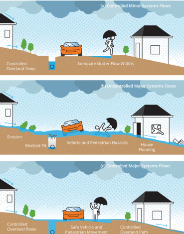
Figure 1: Example of minor-major urban stormwater infrastructure
We should be mindful that insurance does not mitigate the risks of injury or damage from flooding. Insurance provides funds for recovery of damages but this risk-transfer mechanism is limited by commercial viability and affordability constraints. Our opportunity to improve flood risks and associated damage costs lies in land use planning and building policies, modern engineering and floodplain management authorities.
Maximum authority assumptions and new application of models
Recent flooding disasters (such as the Northern Rivers of NSW) and the rapid advancements in flood modelling capability (for example hydraulic models) have been central to an understandable quest by authorities to make assumptions that lead to estimates of the highest flood levels across urban areas and for zero changes in flood levels in development.[37] Our traditional flood modelling methods are well understood for riverine or mainstream flooding but encounter considerable uncertainty when applied to upstream inner urban areas and when faced with multiple sources of flooding.[38] Our ability to reliably estimate flood risks is improving but cannot demonstrate zero (0.000 m) change in flood inundation from a development scenario, which are emerging requirements in Planning Schemes. However, the outputs from emerging hydraulic models used to map flooding overlays do need careful interpretation at the local scale to avoid over-estimated flood risks to properties.[39]
A requirement by authorities for hydrologists to assume cumulative maximum floods and to exclude flood management infrastructure from assessment of flood risk is creating planning overlays of excessive flood depths within urban areas. For example, the dependence between catchment flooding and tidal storm surge is weak and statistically insignificant along the Victorian coast and for Melbourne.[40]
In this situation, modelling that assumes 1% AEP peak flood depths from a river, a local catchment and tidal storm surge occur at the same time will actually produce a planning overlay for 0.01%–0.0001% AEP peak flood depths. This is a flood risk (1 chance in 10,000 to 1,000,000 of occurring in any year) that is massively outside of current planning and legislative understanding. The application of climate change multipliers and additions to these excessive assumptions is unrealistic.
BLANKET OVERLAYS OF FLOOD RISKS
The concerns about excessive flood extents and depths in planning schemes and building permits is heightened by the application of generalised or blanket overlays that include substantial areas that are not subject to inundation. For example, water depths that are mostly confined to the normal operation of road profiles (major stormwater systems) are sometimes used to apply a flood overlay to surrounding land that is normally dry. The blanket approach to setting overlays and excessive flood levels can obscure additional information such as depth, hazard or direction of water flow, and opportunity for mitigation. These approaches can also apply flood risks to the wrong locations and under-estimate flood risks at other locations.
ARE EXCESSIVE ASSUMPTIONS CONSERVATIVE AND EQUITABLE?
The impacts of the emerging excessive assumptions in flood modelling that underpin urban planning overlays are justified as conservative and as the beneficial capture of more properties within authority approval processes. This is assumed to improve the flood risks that impact on properties. However, substantially over-estimated flooding overlays have strong impacts on land value, insurance premiums, mortgage payments, approval impacts and legal costs.
It will be difficult, expensive and unlikely that a landholder or permit applicant can convince the responsible authority to revise excessive or incorrect flood depths or reinterpret a blanket planning overlay.
A WAY FORWARD
We need a Pareto (balanced) analysis of costs and benefits to incorporate these trade-offs and achieve equity in finding the acceptable flood risk for particular locations.[41]
There is a need to prepare for rare flood events and to develop a reliable and defensible understanding of the potential impacts. However, there is also a requirement for normal activity between contested rare events that is more aligned with flood resilience approaches. We should not be sterilising high value land from human endeavour by an unduly conservative application of flood models, planning overlays and building assessments.[42]
Professor Peter J Coombes is a director of Urban Water Cycle Solutions, an honorary and visiting professor at the Crawford School of Public Policy at Australian National University, a fellow of Engineers Australia and an editor of the Urban Book of Australian Rainfall and Runoff. He holds a PhD in civil and environmental engineering systems and has qualifications in surveying, engineering, economics and law. EMAIL peter@uwcs.com.au WEBSITE urbanwatercyclesolutions.com.
[1] Commonwealth of Australia (2020), Royal Commission into National Natural Disaster Arrangements Report (28 October 2020).
[2] D Mackellar ‘Core of my heart’, The Spectator, London, 1906.
[3] NSW Independent Flood Inquiry, 2022 Flood Inquiry (Report, 29 July 2022).
[4] KPMG, Resilience in times of change: General Insurance Industry Review 2023 (March 2023).
[5] The Senate Environment and Communications References Committee, Current and Future Impacts of Climate Change on Housing, Buildings and Infrastructure (Report, August 2018).
[6] P Hannam, ‘Australians facing prohibitive insurance premiums after climate-related disasters’, The Guardian (12 November 2022) <https://www.theguardian.com/australia-news/2022/nov/12/australians-facing-prohibitive-insurance-premiums-after-climate-related-disasters>.
[7] K Al Khawaldeh, ‘Extreme weather and rising premiums make parts of regional Australia “uninsurable”’, The Guardian (19 May 2023) <https://www.theguardian.com/australia-news/2023/may/19/extreme-weather-and-rising-premiums-make-parts-of-regional-australia-uninsurable>.
[8] B Shorten, ‘Standard Definition of Flood Regulations Finalised’ (Media Release 18 June 2012) <https://ministers.treasury.gov.au/ministers/bill-shorten-2010/media-releases/standard-definition-flood-regulations-finalised>. Also see Insurance Contracts Regulation Act 1984 (Cth), s37B(2)(a).
[9] LMT Surgical Pty Ltd v Allianz Australia Insurance Ltd [2013] QSC 181.
[10] J Ball et al (eds), Australian Rainfall and Runoff: A Guide to Flood Estimation, Commonwealth of Australia (Geoscience Australia) 2019.
[11] P Box, F Thomalla F, and R van den Honert, (2013), ‘Flood risk in Australia: Whose responsibility is it, anyway?’ Water, Vol 5, No 4, 1580–1597.
[12] PJ Coombes and S Roso (eds), Australian Rainfall and Runoff: A Guide to Flood Estimation, Book 9: Runoff in Urban Areas, Commonwealth of Australia (Geoscience Australia) 2019.
[13] Australian Government Bureau of Meteorology and CSIRO, ‘State of the Climate 2022’ (Report).
[14] Climate Council of Australia, Uninsurable Nation: Australia’s Most Climate-Vulnerable Places (Report, 2022).
[15] Intergovernmental Panel on Climate Change (IPCC), AR6 Synthesis Report: Climate Change 2023 (March 2023). SSPS scenarios used to derive emissions scenarios without and with climate policies; RCP emissions scenarios used to derive climate change projections.
[16] Commonwealth of Australia, State of the Environment (Report, 2021).
[17] Wayne Tank & Pump Co Ltd v Employers Liability Assurance Corporation Ltd [1974] 1 QB 57 (Wayne Tank).
[18] Water Act 1989 (Vic), s204.
[19] The State of Victoria Department of Environment, Land, Water and Planning, Guidelines for Development in Flood Affected Areas, February 2019.
[20] Ball et al (eds), above note 10.
[21] A Godber, ‘Urban floodplain land-use – acceptable risk?’ The Australian Journal of Emergency Management, Vol 20, No 3, August 2005.
[22] Wayne Tank, above note 17.
[25] The State of Victoria Department of Environment, Land, Water and Planning, Guidelines for Development in Flood Affected Areas, February 2019.
[26] Ball et al (eds), above note 10.
[27] State of NSW and Office of Environment and Heritage, Floodplain Risk Management Guide, 2019.
[28] NSW Independent Flood Inquiry, above note 3.
[30] Ibid.
[31] [2018] QSC 123 (Wiesac).
[32] Wayne Tank, above note 17.
[33] Wiesac, above note 31.
[34] Ibid, [73]–[74], [105], [172].
[36] PJ Coombes and S Roso (eds), above note 12.
[37] PJ Coombes and A Allan, ‘Is zero afflux the question or answer to better flooding outcomes?’ Hydrology and Water Resources Symposium 2022: The Past, the Present, the Future, Engineers Australia.
[38] Ibid.
[39] PJ Coombes, ‘Application of joint probability to respond to climate change and avoid cumulative extreme assumptions’ (Hydrology and Water Resources Symposium 2023 ‘Living with extremes’, Engineers Australia, 12–15 November 2023).
[40] W Wu et al, ‘Mapping dependence between extreme rainfall and storm surge’, Journal of Geophysical Research: Oceans, Vol 123, No 4, 23 March 2018, 2461–2474.
[41] AE Boardman et al, Cost-Benefit Analysis: Concepts and Practice, Prentice Hall, United Kingdom, 2014. Pareto optimum is defined as a solution that improves the outcomes for everyone while leaving no one worse off.
[42] Stock Corporation Pty Ltd v Yarra CC [2020] VCAT 958.
AustLII:
Copyright Policy
|
Disclaimers
|
Privacy Policy
|
Feedback
URL: http://www.austlii.edu.au/au/journals/PrecedentAULA/2023/50.html